
-
Government
- Advisory Boards, Commissions and Committees
- Meeting Agendas and Minutes (2020 - Present) (opens in a new tab)
- Code of Ordinances (opens in a new tab)
- Mayor & City Council
- Public Comment
- Public Notices & Hearings
- Transparency
- Election Information
- Accessibility
- Title VI and ADA
- Document Archive (Historic Minutes 1933-2019, Documents, Resolutions, Annexations, and other Files) (opens in a new tab)
- Departments
-
Residents & Visitors
- Alert HVL
- City News
- Downtown Hendersonville
- Emergency Preparedness
- Events Calendar
- Get Connected
- Henderson County Tourism (opens in a new tab)
- Hendersonville Historic Preservation
- Motor Vehicle Tax (opens in a new tab)
- Parking
- Parks & Recreation
- Property Tax
- Recognize an Employee
- Report a Problem
- See Our City
- Staff Contact Directory
- Start Water / Sewer Service
- Stop Water / Sewer Service
- Voting Information (opens in a new tab)
- Waste Pickup & Recycling
- City Resources
- Businesses
- Downtown

Lower Mud Creek Floodplain Restoration Project
Cover Image
Body
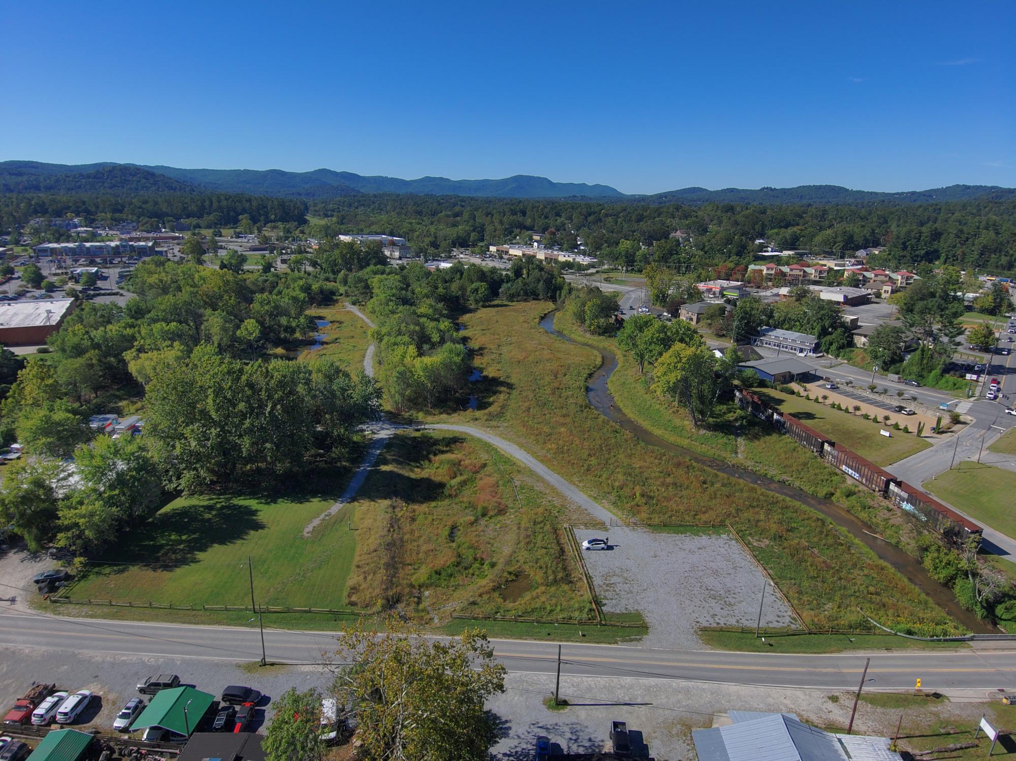
The City of Hendersonville celebrated the completion of Phase 1 of the Lower Mud Creek Floodplain Restoration and Flood Risk Reduction Project with a ribbon-cutting ceremony and walking tour on Friday, October 30, 2026, at 519 S. Grove Street.
The project transforms approximately 27 acres of City-owned floodplain along Mud Creek into restored wetlands, streams, floodplain habitat, and publicly accessible green space. Designed to work with the natural landscape, the project reconnects Mud Creek and its tributaries to their floodplain, creating additional space for floodwater while improving water quality, aquatic habitat, and recreational access.
“This project represents a different way of thinking about floodplain management and community resilience” said Michael Huffman, Stormwater & Parks Director for the City of Hendersonville. “Rather than trying to move water downstream as quickly as possible, we are giving it room to spread out in a place that is naturally intended to flood. At the same time, we’ve been able to restore habitat, improve water quality, and create a space the community can enjoy.”
City Council members, community supporters, funding partners, and North Carolina Department of Environmental Quality (DEQ) Secretary Reid Wilson gathered for the ceremony and walking tour, officially opening the restored area for the community to enjoy.
"We are cutting a ribbon on a project that will strengthen resilience against flooding and provide numerous other benefits," said DEQ Secretary Reid Wilson. "This project combines two of DEQ's top priorities, helping Western North Carolina recover from Helene, and strengthening communities' resilience to disasters throughout the state."
Mud Creek has a long history of flooding. Beginning in the 19th and early 20th centuries, portions of the creek were straightened, dredged, and bermed in an effort to drain the valley and reclaim land for agriculture and development. Over time, commercial development, floodplain filling, and modifications to the stream system reduced natural flood storage and further disconnected the creek from its floodplain.

The City acquired the two project properties in 2002 in part to preserve flood storage and reduce future development within this flood-prone area. More than two decades of watershed planning, environmental restoration efforts, grant development, engineering, and partnerships ultimately led to construction of the Lower Mud Creek project.
Major project components include approximately 2,300 linear feet of tributary stream restoration, 1,500 linear feet of channel restoration on Mud Creek, 8.5 acres of wetland restoration, and approximately 9.2 acres of riparian floodplain restoration and enhancement. These improvements reconnect floodplain areas previously separated by berms and create wetlands that store and gradually release stormwater during smaller storms, while providing space for floodwater to spread across the broader floodplain during larger events. The project also includes water-control structures, native vegetation, pedestrian bridges, approximately 2,500 linear feet of paved greenway, and approximately 1,600 linear feet of natural-surface trail.
The restored floodplain is expected to provide approximately 20 acre-feet of additional flood storage and contribute to reduced flood risk for as many as 93 nearby properties representing approximately $60 million in assessed value.
Construction also reconnects areas previously separated by berms and creates wetlands capable of storing and slowly releasing stormwater during smaller events while allowing the broader floodplain to function during larger floods.
“The most important lesson from this project is that flood resilience does not have to be a single-purpose investment,” Huffman said. “When we plan around natural systems, a flood mitigation project can also be a water-quality project, a habitat project, a greenway project, and a community investment.”
The project was made possible through partnerships and funding from the North Carolina Division of Water Infrastructure, North Carolina Land and Water Fund, North Carolina Water Resources Development Grant Program, North Carolina Flood Resiliency Blueprint, and the City of Hendersonville.
Wildlands Engineering served as the project engineer, and Shamrock Environmental served as the construction contractor. Additional project partners include Land of Sky Regional Council, EcoForesters, and other technical and regulatory partners.
Search
Press Escape to close this dialog.